The U.S. Army Corps of Engineers (USACE) and other groups have had long-standing navigational concerns over Jekyll Creek, which is part of the Atlantic Intracoastal Waterway. Historically, it has been the shallowest point in the more than 160 miles of Georgia’s portion of the waterway. In April 2019, a contractor for the USACE began dredging Jekyll Creek from north of Downing Musgrove Causeway to the St. Simons Sound. Prior to this, Jekyll Creek had not been dredged since 1998. This $6 million, federally funded project brought the depth of the eastern 75 feet of the channel to 10 feet.
Cottrell Contracting, of Chesapeake, VA, removed approximately 200,000 cubic yards of sediment from the channel. The removed sediment, fine-grain material with very low sand content, often called “pluff mud,” was placed in two locations using new methods meant to keep Georgia’s sediments in the coastal system and to help elevate marsh to increase resilience to sea level rise. Traditionally, dredged sediments are transported inland or offshore away from the dredging area, which is costly and provides no ecological benefits. The aim of this pilot project was to test economically efficient and environmentally acceptable methods of managing dredge material.
The first sediment-placement location was north of Jekyll Creek in the St. Simons Sound, about 800 feet south of the St. Simons Pier. This location, commonly called the “Deep Hole,” is naturally deeper than surrounding areas in the sound and is between 60 and 80 feet deep. For comparison, other areas in the channel are dredged to about 38 feet deep. Nearly 97 percent of the dredged sediment was placed by pipe within five feet of the bottom of the Deep Hole, where tidal currents naturally dispersed the sediment.
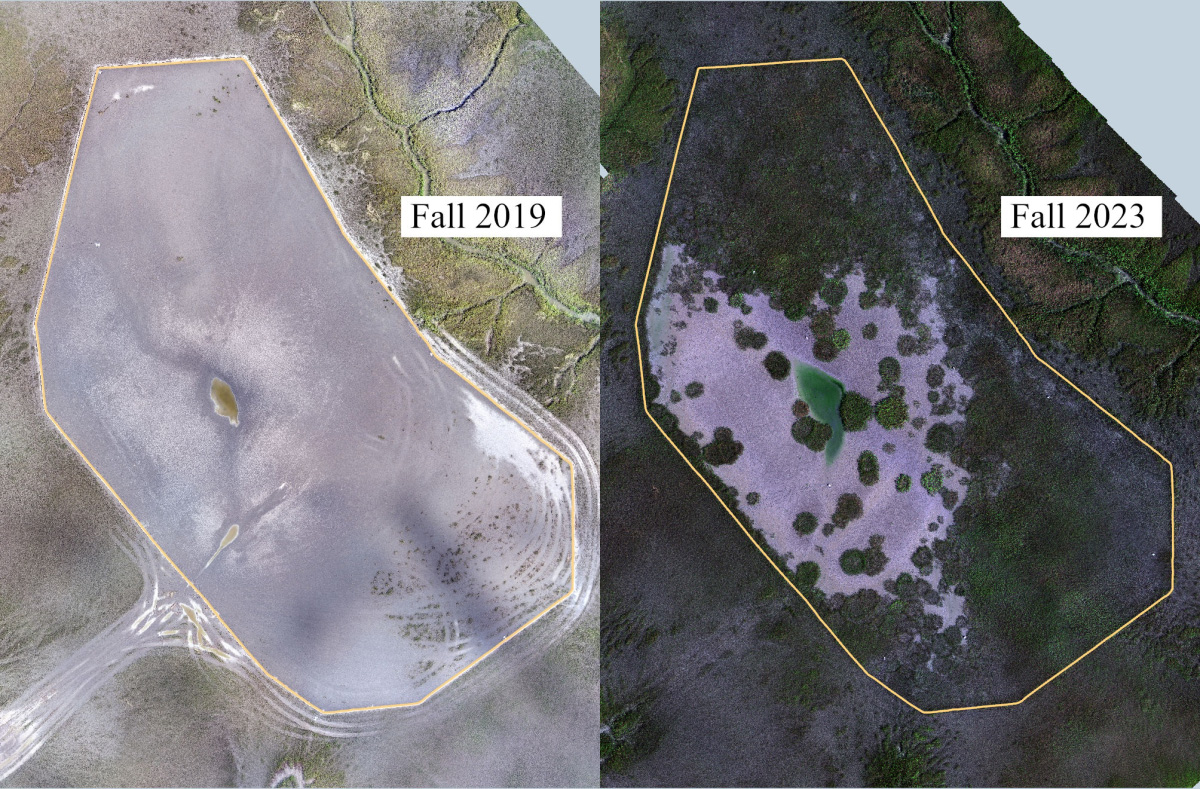
The remaining 5,000 cubic yards of material was placed in a pre-identified 5-acre area of marsh off Jekyll Creek, north of the Jekyll Island Airport. Salt marsh vegetation is adapted to being partially submerged in salt water for a portion of the tidal cycle, however, higher sea levels could cause the vegetation to become flooded for too long and reduce productivity and health. The goal of placing dredged sediments into this area was to encourage marsh grass to grow at higher elevations, reducing the probability that the marsh grass will be degraded by increased saltwater inundation. By 2024, nearly 80% of the marsh grass had regrown at the higher elevation. Monitoring is ongoing and we anticipate the area will be fully restored over the next 5 years.
The sediments were pumped into the marsh to form a 6 to 9-inch-high layer. The area where sediments were deposited was surrounded by coconut-fiber logs to prevent overflow of sediment into the surrounding marsh and tidal creeks. The sediment placement was completed April 22, 2019.
Another five-acre location to the north was selected as a reference area so any changes to the marsh in the placement area could be compared to untreated marsh. Scientists from Georgia Southern University and the University of South Carolina monitored the placement and reference areas for a three-year period. Biologists from Georgia DNR Coastal Resources Division have also been collecting Unmanned Aerial Vehicle (UAV) imagery (below) to monitor vegetation recolonization in the years since the sediment placement.

The USACE has had success with thin-layer placement in New Jersey, Maryland and Louisiana, but has not attempted to use the technique to elevate healthy marsh in Georgia before this project. The goal of the project partners is to proactively explore whether this technique can be used more widely in the future to build a more resilient Georgia coast.
For an overview of TLP best practices and summaries of example projects from other areas of the United States, check out the Georgia Coastal Research Council's white paper on Thin Layer Placement
In designing this pilot strategy, USACE Jacksonville and Savannah districts worked with the Corps’ Regional Sediment Management Center of Expertise, as well as other federal, state, and nonprofit agencies. The Georgia Department of Natural Resources’ Coastal Resources Division (CRD), the Jekyll Island Authority (JIA), The Nature Conservancy (TNC), the National Oceanographic and Atmospheric Administration (NOAA), the U.S. Fish and Wildlife Service and the U.S. Environmental Protection Agency (EPA) were all involved in the planning. The process began in 2016 with a visit to Jekyll Creek by the Corps’ South Atlantic Division commander. In subsequent months, the Corps held stakeholder meetings and public information meetings while coordinating with CRD and JIA. CRD helped by collecting imagery and elevation data at the thin-layer placement site. JIA and TNC purchased an elevated monitoring camera system to provide imagery of the project as it progresses. View the camera feed
The following videos offer a useful overview of the project. However, they were produced during the planning stages, and details of the implementation have changed since then.


