What Are They?
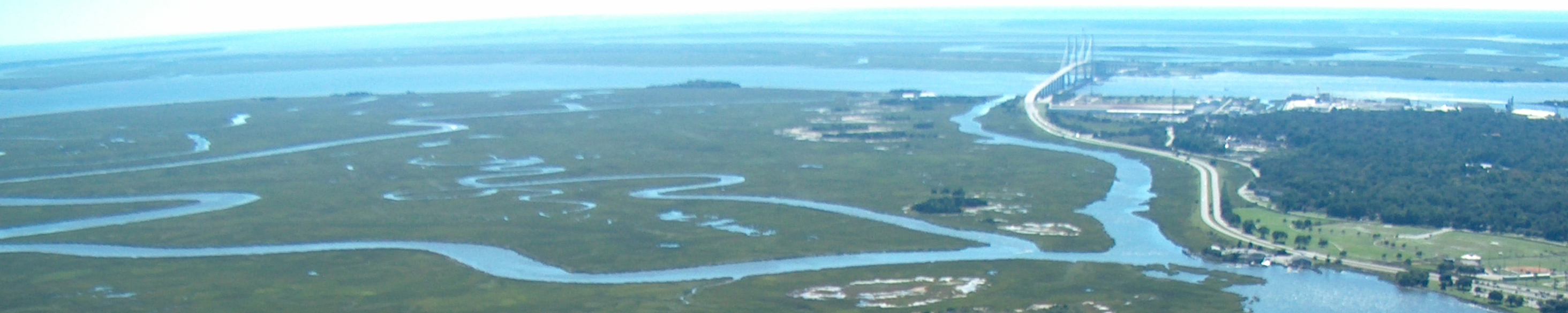
Barrier islands are among the most beautiful and precious features of our coastline. A barrier island is defined as a long, offshore, dune-covered deposit of sand lying roughly parallel to and separated from the mainland by a shallow sound (lagoon) and/or salt marsh; barrier islands are separated from each other by tidal inlets. Our present barrier islands have evolved over thousands of years and are a wonderful example of a delicate but balanced system in a constantly changing environment.
Thirteen percent of the world’s coastlines and more than one-third (33%) of the coast of North America is bordered by barrier islands. Along the Atlantic coast alone there are more than 300 barrier islands and spits (a spit is similar to a barrier island but is smaller and attached to the mainland) extending along the coasts of 18 states from Maine to Texas. Each barrier island is different and unique in its own way and although no two are exactly alike, they may have many similarities.
A typical mature barrier island consists of several distinct features or habitats including the ocean, beach, berm, primary dunes, secondary dunes, interdune meadows, shrub zone, maritime climax forest, salt marsh, tidal (or mud) flats and sounds. Many barrier islands also have freshwater sloughs that form in low areas and between old dune ridges. Each habitat, although existing in close proximity to the others, has its own unique characteristics.
Importance of Barrier Islands
Barrier islands are called “barrier islands” because they create a barrier between the mainland and the ocean. They shelter and protect the mainland from the powerful forces of wind, waves, tides, currents and the ravages of storms and hurricanes. They shelter the estuaries that form behind the barriers. Between 75% and 95% of all marine species are dependent upon these estuaries at some point in their lives. They allow marshes to build up in the quiet waters of the sound. The marshes filter the pollutants that come in from mainland rivers and when the marsh grasses die they create detritus, a valuable food source for small marine organisms.
Barrier islands provide valuable habitats for mammals, shellfish and fish including many endangered species, and offer a greater variety of bird species than any other ecosystem in the continental United States. They also serve aesthetic purposes and for years, have inspired artists, poets, writers, bird watchers, boaters, picnickers, sunbathers and swimmers.
Barrier islands are truly a most valuable resource. It is remarkable that although they constantly change and may become badly eroded (some even disappear entirely), they can rebuild if left alone.
Barrier Island Geology and Formation
There are several theories as to how barrier islands form. Georgia’s barrier islands are thought to have formed as the result of world-wide sea level fluctuations caused by alternating periods of warm and cold during the Pleistocene Epoch that allowed great continental ice sheets to advance and retreat over the Northern Hemisphere. During glacial advances, huge amounts of water were locked in glaciers causing the sea level to fall. Then, during interglacial periods when it was warmer, the ice melted, causing sea level to rise.
Georgia was never covered by glaciers but it was affected by the rising and falling of the sea level about 40 million years ago. During the Pleistocene, in warm periods, sea level may have been as much as 50 to 100 feet higher than today with the ancient coastline lying along a sand ridge known as Trail Ridge. During times of extreme cold, the shoreline lay as much as 80 miles seaward of its current position.
One theory suggests that Georgia’s present barrier islands may have formed during several consecutive periods of glacial melting. The older islands formed thousands of years ago when sea level rose flooding the coastline. (Dates for their formation are unclear and could have been any where from 25,000 to 100,000 years ago.) Ridges of sand dunes were left above sea level and gradually built into barrier islands. Over the next few thousand years sediments from rivers added material to fill in the area between these new islands and the mainland producing mud in which the vast expanses of salt marsh formed. As sea level stabilized these small remnants of old sand dunes gradually built into our older barrier islands. About 11,000 years ago near the end of the Pleistocene, sea level rose again, flooding the coastline to its present location. About 5,000 years ago the rise in sea level slowed to about four to six inches per century, allowing the formation and growth of our newer Holocene islands. Over the last few thousand years sediments from rivers and the islands’ natural landward migration have filled in or partially filled in the area between these older and younger sets of islands. Today sea level is rising a little more than one foot per century.
Each period of ice formation and melting created a new sequence of barrier islands along the coast of Georgia. The oldest series of islands, the Wicomico Shoreline, formed when sea level was as much as 95 to 100 feet higher than it is today and is responsible in part for the creation of the Okefenokee Swamp. The next series of barrier islands, called the Penholoway Shoreline formed when sea level was 70 to 75 feet above its present level. The Talbot shoreline formed when sea level was 40 to 45 feet higher; the Pamlico shoreline formed when sea level was 25 feet higher. The Princess Anne shoreline formed when sea level was 15 feet higher, the Silver Bluff shoreline formed when sea level was 5 feet higher.
Courtesy of the Sapelo Island National Estuarine Research Reserve
www.sapelonerr.org
Written by Margaret Olsen
GO BACK A PAGE
RETURN TO HOME


